Current Location
(enter callsign KG6NNZ)
Logbook: Galapágos Islands, Ecuador, May to June 2010
Our passage to the Galápagos Islands was the first leg in our journey that would take us to the South Pacific. There's literally no place like the Galápagos in the world, and it's been on our list of places we've wanted to visit for a long time.
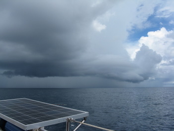
Passage from Isla Pedro Gonzalez, Perlas Islands, Panama, to Wreck Bay, Isla San Cristóbal, Galápagos (May 4 to 12, 980 nm, 8 days and 3½ hours). The passage from Panama to the Galápagos presents some challenges, including headwinds, light winds, or sometimes no wind at all, as well as strong currents. The islands lie in a southwesterly direction from Panama, and the winds are usually blowing from that direction. We don't carry enough fuel to motor the entire distance, nor did we want to, so we needed to figure out the best way to use our sail power. The generally recommended course is to first sail south from the Bay of Panama toward the Colombian island of Malpelo (about 300 miles). Passing east of Isla Malpelo usually allows one to stay out of the worst of the north-setting Humboldt Current that runs up the coast from South America and sometimes pick up a helpful countercurrent. Once past Isla Malpelo, the winds generally back to the south, and one can then sail a west-southwesterly course toward the Galápagos. Closer to the Galápagos, the winds usually back further to the southeast, making the final leg of the trip a beam reach. At least, that's how it's supposed to work!
| Sailing south toward Isla Malpelo with strong southwesterly winds would be uncomfortable, so we looked for a weather window with lighter winds - no more than 15 knots. An ideal weather forecast for this departure would include north winds, but those are more prevalent in the winter months and harder to find in the spring. North winds did appear in the forecast while we watched the weather for this passage, and we were hoping to take advantage of those, but each day the forecast showed them arriving a day later, and we finally gave up on them. We weighed anchor and departed Isla Pedro Gonzalez on glassy calm seas early the morning of May 4, setting our course south for Isla Malpelo. A couple hours after departure, a light breeze came up from the east, and we turned off the engine and started sailing under main and jib, but we put a reef in the main as we were keeping our eyes on the east sky and a squall that was headed our way. The squall was upon us shortly thereafter, but the maximum wind in it was 25 knots, so it wasn't too bad. In fact, it was a good squall because it gave us a couple hours of great sailing. With a current running in the direction we were headed, our speed over ground was over 8 knots. The great sailing was short-lived however, as by early afternoon, the wind completely died, and we turned on our engine. For the next four days, with the exception of a few hours of light breezes allowing us to drift slowly under sail and one squall that gave us good wind for about four hours, the winds were calm, and we motored south. For the first couple of days, we had the Humboldt Current working against us (about 1 knot), but we eventually found the countercurrent that runs on the east side of Malpelo and that gave us a little boost (about ½ knot). |
|
Once we passed Isla Malpelo, at the direction of the local weather forecaster named Karsten, we turned and motored southwest still in search of wind, keeping an eye on our dwindling fuel supply. On the morning of the fifth day, the wind finally showed up. It started out light (6-8 knots) and came from a southwesterly direction, but we were able to sail a westerly course. After a few hours, the wind backed to the south, and then we were able to sail a southwesterly course to our destination. This was all working out quite well until late in the evening on day 6 when we noticed that although we were still sailing on the heading to our destination, our cross-track error had increased significantly, and our actual course over ground was about 20 degrees north of the Galápagos Islands. We had run into a strong north-setting current. We mentioned it to Karsten, and he advised us that the currents in that area were very unpredictable, so he was unsure how long it would last. We tried to tack and make some southing, but the current was so strong, we could only point east, and that would take us back toward the mainland, which is not the direction we wanted to go! We then tried turning on the engine and motoring toward the Galápagos, but with the current setting us north, that put the wind directly on our nose. It was blowing about 15 knots, the ride was bumpy and uncomfortable, the current slowed us down, and we didn't think we had enough fuel to motor the distance. We went back to sailing as close to the wind as possible with our course over ground taking us north of the islands. Since we were getting closer to the Galápagos, normally the winds should back to the southeast, which would have solved our problem, but our forecasts weren't showing any southeast winds in the next few days, only south winds. Fortunately, the forecasts did show that the winds would lighten up in a couple of days. In the end, we sailed until we were within 100 miles of the Galápagos. By that time, we were directly north of where we wanted to be, but the winds died down to less than 10 knots, the seas were calm, and we were able to motor to our destination. We arrived in Wreck Bay with about 40 gallons of fuel to spare. (Our tank capacity is 168.)
This fishing gods were very unkind to us on this passage. We hooked a couple of skip jacks in the Bay of Panama (one which bit on our lure while Rich was putting it in the water!), but we threw those back because they're not all that good eating. We dragged a line, sometimes two, during this entire passage, and we had a few big hits. Unfortunately, we never landed any of those big hits, and worst of all, we lost three lures - a brand new rattlejet, an old cedar plug that's served us well, and another feather. Bummer!
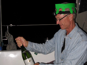
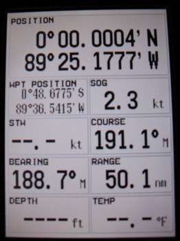
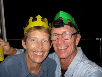
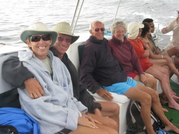
On the last night of our passage to the Galápagos, we had a celebration on board Slip Away. We sailed across the equator, which elevated our status among sailors from "polliwog" to "shellback." Although we normally don't drink alcohol while underway, we had a bottle of champagne in the fridge for this occasion. We crossed the equator shortly after midnight on the last day of our passage. We donned our party hats, toasted and offered champagne to King Neptune, and then each drank a glass ourselves. Since we would be arriving at our destination the next morning, we put the leftover champagne back in the fridge to save for our arrival.
|
|
|
|
| In addition to becoming shellbacks on this passage, we also became grandparents! Our first grandchild, Peyton Marie Crowell, was born on May 6 to Rich's oldest son Andrew and his girlfriend Katie. Everyone is healthy and happy, and we look forward to meeting her on our next trip back to the States. |
|

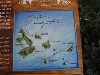
Galápagos Islands
| The Galápagos are an isolated
group of volcanic islands that lie in the Pacific Ocean on the equator.
They are owned by Ecuador, which is the nearest mainland lying about 1000 km
(over 600 miles) to
the east. The archipelago was discovered by accident in 1535 when Tomas de Berlanga, the first bishop of Panama, drifted off course while sailing from
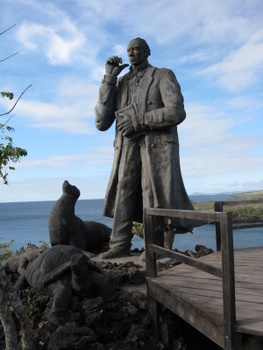
Panama to Peru. The Galápagos' most famous visitor was Charles Darwin, who
sailed among the islands on the British Naval vessel the Beagle for five weeks
in 1835. In 1859, Darwin published his theory of evolution in his book
Origin of the Species. The notes he made and specimens he
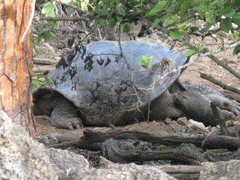
collected in the Galápagos provided important evidence for his theory. This remote chain of islands is home to an amazing variety of wildlife, including many species found nowhere else on earth. However, every plant and animal species originally arrived in the Galápagos from somewhere else via wind, air or sea currents. Today, many of the species are threatened or endangered. For more than 300 years after their discovery, the Galápagos were used by pirates, sealers and whalers, and the giant tortoise and fur seal populations were decimated. Ecuador officially claimed the Galápagos in 1832, and for the next 100 years, the islands were inhabited by only a few settlers and were used as penal colonies, the last of which was closed in 1959. Some islands were declared wildlife sanctuaries in 1934, and 97% of the archipelago officially became a national park in 1959. |
|
Ecuador faces strong challenges in preserving and restoring the flora and fauna species. Many of the species are in peril, but more than 95% of those inhabiting the islands before human contact still exist, and only 1% are completely extinct. Plant and animal species introduced on the islands (e.g., feral pigs and goats) threaten survival of endemic flora and fauna, and they are working toward their elimination. Tortoise populations have increased dramatically through breeding centers established on several of the islands. The government is working to find a balance for the Galápagos Islands by focusing on a combination of environmental education for both residents and visitors, and a program of responsible and sustainable tourism.
When traveling to the Galápagos on a private yacht, there are a couple of options. One can purchase a cruising permit (called an autografo) which must be arranged before arrival, but it is also possible to visit the islands without a cruising permit. When a boat arrives without a cruising permit, the individuals on board are allowed to stay in the islands up to 20 days, but the boat must remain in the port of arrival only. Since we expected this visit to the Galápagos to be a once-in-our-lifetimes visit, we chose to get the cruising permit. Our autografo allowed us to stay in the Galápagos up to 45 days, and we were allowed to take Slip Away to three different islands - San Cristóbal, Santa Cruz and Isabela. We arranged our autografo through Naugala Agency (Bolivar & Grace Pesantes), which came highly recommended from other cruisers.
Although the Galápagos lie on the equator, the climate is not tropical hot and humid. The islands have two seasons - the warm/wet season from January to May, when the average air temperature is 77º F (25º C) and the cool/dry season, when air temperatures average around 72º F (22º C). The seas are warmer during the warm/wet season, but they're always a bit chilly by our standards. The Humboldt Current keeps the waters (and thus the air) cool in the islands. During our visit, daytime temps were warm, and the air was dry -- t-shirt and shorts weather -- but we usually needed a long-sleeved shirt or light jacket in the evenings. Surface water temperatures were in the low to mid 70's F, which is significantly cooler than what we are used to swimming and diving in. (We prefer and have gotten quite used to water temperatures that average around 80º F.)
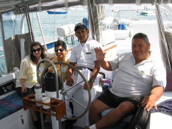
Puerto Baquerizo Moreno (aka Wreck Bay), Isla San Cristóbal (May 12 to 18). We arrived Wreck Bay mid-morning, found a good anchoring spot and then Jan cooked up Rich's favorite post-passage breakfast - spam and eggs. This morning, we had a special treat because we had the leftover champagne to drink with it. We had barely eaten the last bite when a boatload of officials showed up at Slip Away - Bolivar from Naugala Agency, Victor from the Port Captain's Office, and Sylvia & Elie from the Fumigation/Agriculture Department. We answered their questions, provided our exit documents from Panama and filled out the requisite paperwork. Sylvia asked to inspect the boat, primarily wanting to see what fruits and veggies we had brought with us. Jan showed her the items she wanted to see in our fridge, and then she asked to see our v-berth (which serves mostly as a storage area). She was quite impressed with the crate of beer we had stored there, and asked if she could have a couple. Jan was somewhat surprised by this request, but not wanting to offend the officials, she gave up two of our precious stash. (Although we had bought several cases of beer in Panama, it needed to last us several months, so we didn't have a lot of extras to share!) After finishing up the paperwork on the boat, we went ashore where Bolivar took us to the Immigration office to get our visas, and then he relieved us of a big chunk of cash - cruising permit/autografo ($300), National Park passes ($200), immigration visas ($60), and fumigation fees ($30) and port captain charges ($170) - at total of $762. Ouch!!
|
|
|
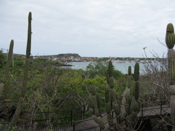
The town of Puerto Baquerizo Moreno on Isla San Cristóbal is the capital of the Galápagos Islands. Isla San Cristóbal is the fifth largest island, and Puerto Baquerizo Moreno has the second largest population (10,000) in the island group. Along the waterfront, there is a beautiful malecón (boardwalk) which was newly restored in 2006. The town is clean and appears prosperous, the people are friendly, and we found good and reasonably priced restaurants, ice cream and laundry (all important items for cruisers). We didn't need to purchase any provisions here, but the town had a supermarket, as well as some other smaller tiendas, and we heard very good reports on their market for fresh fruits and veggies.
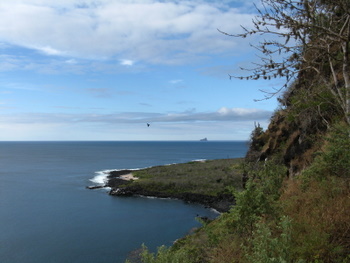
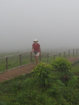
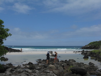
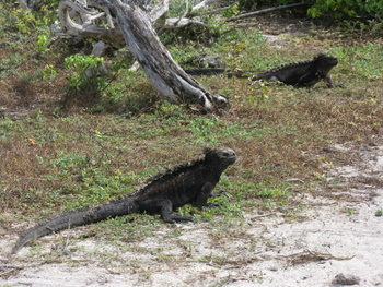
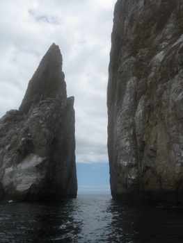
We spent six days in Wreck Bay and did some great sightseeing. We walked out to the Interpretive Center, which provided an overview of natural history, human history and conservation efforts. There were some very nice trails around the Interpretive Center, and it was a good opportunity to give our legs a little workout, take in some beautiful views of the shoreline, and see frigate birds and finches. We also did a "highlands tour" with three other couples and visited several sights, including La Loberia, (a beach with lots of sea lions and marine iguanas), Puerto Chino (another beautiful beach where some of our fellow travelers opted to go for a swim), Centro de Crianza (a giant tortoise breeding center), and Laguna El Junco (a fresh-water lagoon inside an inactive volcano crater). Another day, we went scuba diving at Kicker Rock, but that was mostly a disappointment because the water was cold (68º F at a depth of 50 feet) and murky, and we didn't see the hammerhead sharks, which was the main attraction. Fish life was good on the dive, but we'd rather look at fish in warmer, clearer water. We did see a marine iguana in the water while snorkeling that day - pretty cool.
|
|
|
|
|
|
|
|
|
|
|
|
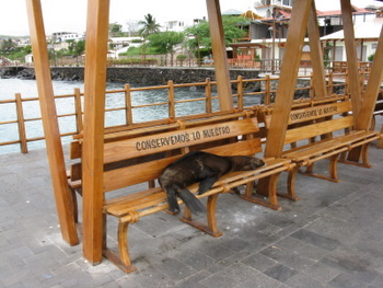
Some of the best entertainment in Wreck Bay was free - watching the sea lions. It felt like there are as many sea lions as people here, and they are not at all shy! There were always several sea lions hanging out on the malecón - sleeping on or under the benches, or awkwardly "strolling" along the walkway. Catamarans and boats that have stern steps into the water had to put up blockades to prohibit sea lions from coming aboard. We had several friends who had visitors on board, often in the middle of the night. Sea lions also tended to make use of dinghies sitting in the water. There was inexpensive water taxi service, so we left our dinghy in the davits and used the taxi. Sea lions are cute, but they make a mess!
|
|
|
Passage from Wreck Bay to Puerto Ayora (aka Academy Bay) (May 18, 43 nm, 9 hours). Our next port of call was Puerto Ayora on Isla Santa Cruz. Our friends John & Chris on Sara II (from England) were also intending to visit Puerto Ayora, but they did not have a cruising permit, so they were planning to leave their boat in Wreck Bay, take a ferry to Academy Bay, and spend a couple of nights in a hotel. Rather than have them take the ferry, we were happy to give them a lift on Slip Away. We had nice winds early in the day and were able to sail a good part of the distance before needing to turn on the engine for the last couple hours of the trip. It was fun to have them on board for the passage. John is an extremely experienced sailor, and he helped us with some fine tuning of the sails. It was also quite helpful to have some extra hands on board when we arrived and needed to set a stern anchor, something we hadn't done for a several years.
Puerto Ayora (Academy Bay), Isla Santa Cruz (May 18-21). Isla Santa Cruz is adjacent to Isla Baltra, which is the location of the main airport in the Galápagos, so most visitors pass through here. With a population of 18,000, the town of Puerto Ayora is the largest in the Galápagos. Most of the boat tours of the islands start from here, and the harbor is full of a wide variety of vessels - from small sailing charter boats to larger, more comfortable power yachts (but no huge cruise ships). In addition to all the boat traffic, the harbor has virtually no protection from ocean swell, so the combination of those factors makes this a pretty rocky and rolly anchorage. We knew this going in, but we wanted to see a few of the sights here. Setting a stern anchor helped keep us pointed into the ocean swell, but it was best to spend as little time aboard Slip Away here as possible.
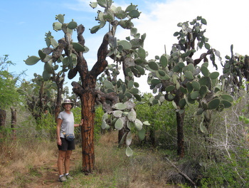
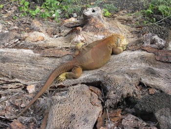
We spent our first day in Academy Bay sightseeing with John & Chris. In the morning, we walked to the Marine Reserve Exhibition Hall, which offered displays on the local marine life and conservation efforts, and then we hiked along a cactus-lined trail and across the beautiful white-sand beach of Playa Brava to Turtle Bay. We saw more marine iguanas, but no turtles. After lunch, we walked out to the Charles Darwin Research Center, where park officials breed giant land tortoises and land iguanas which were on the verge of extinction. The Charles Darwin Research Center is the home of "Lonesome George", the 150-year old tortoise who is the only surviving member of the Isla Pinta subspecies. Scientists have tried to mate "Lonesome George" with tortoises of closely related subspecies, but with no luck.
The next day, John & Chris were headed back to Wreck Bay, so we were on our own. In the morning, we hiked through more groves of cactus out to Las Grietas, a swimming grotto, where we took a refreshing dip in the water. A group of school kids arrived shortly after us, so it was not solitary and quiet, but everyone was friendly and having a good time. After our grotto swim, we had lunch in town and then ran some errands - a haircut for Jan, a trip to the Mercado Municipal to buy some fruits and veggies, and visits to a hardware store and a couple of the other local markets where we picked up a few other provisions.
|
|
|
|
|
|
|
We enjoyed the time we spent on Isla Santa Cruz. We liked the town of Puerto Ayora, and there were more sights to see on the island, but we chose to move on after a couple of days. In addition to the uncomfortable anchorage, other cruisers told us not to dawdle here, as the best was yet to come.
Passage from Academy Bay to Puerto Villamil, Isla Isabela (May 21, 50 nm, 8½ hours). Since we had a fair distance to make to Isla Isabela, and we wanted to enter there with good light, we left Academy Bay shortly before dawn. It was a drizzly morning, and there were a few tour boats coming and going at that time of the morning, but we got out of the bay with no problems. We sailed about three hours, but then the wind died, so we finished the trip under motor. In the last few hours of the trip, we noticed a very large swell running. The entrance to the anchorage at Isla Isabela is surrounded by reefs, and the large swell breaking on those reefs made the entrance appear a bit more exciting than we would have liked. The charts of the area are pretty poor, so we needed to use "eyeball navigation" to get into this harbor, and fortunately we could see a clear path through the breaking waves to enter safely.
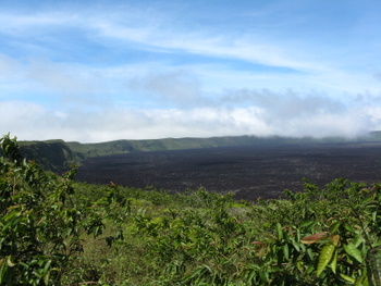
Puerto Villamil, Isla Isabela (May 21 to June 3). Isla Isabela is the hands-down favorite among the cruising community, and it was ours too. The anchorage offers fair protection from the open ocean, there is lots to see and do on the island, and the small town (population 2000) is charming. Isla Isabela is the largest island in the archipelago, and it is made up of a chain of five volcanoes, which are intermittently active.
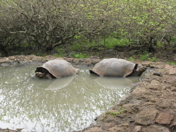
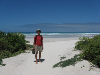
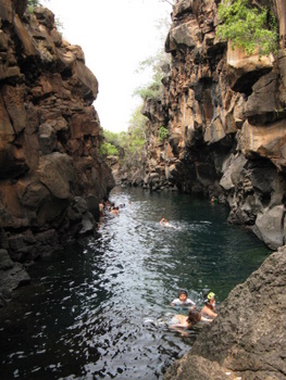
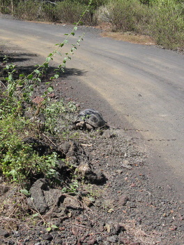
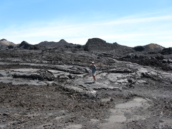
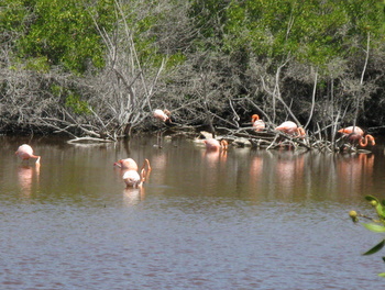
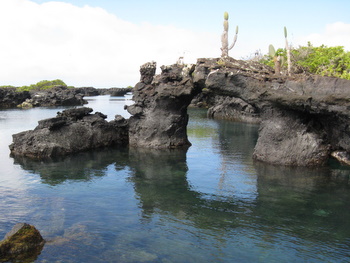
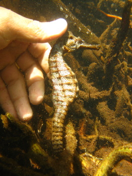
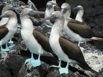
We spent two weeks in Puerto Villamil and found lots to do. We took a hiking tour to Volcán Sierra Negra, which is the second-largest volcano crater in the world (10 km or 6.2 miles in diameter) and most recently erupted in 2005. As part of that tour, we also visited Volcán Chico, which is actually a group of parasitic volcanoes that formed on the side of Volcán Sierra Negra. We also took the highly recommended boat tour to Los Tuneles, where the captain guided us through some beautiful lava tube formations, we watched the antics of several colonies of blue-footed boobies, and we snorkeled with some huge sea turtles, white-tipped sharks, eagle rays and even a couple of sea horses (our guide knew exactly where to find them). We visited Las Tintoteras, a group of small islands made up of rugged lava with some areas where the sea pooled and white-tipped sharks gathered and slept. We swam through one of those pools and it was pretty intimidating to be swimming a few feet above some of those big guys! We walked along a boardwalk which wound through mangroves and alongside lagoons where we saw wading birds, including pink flamingoes. This boardwalk ended at the Crianza de Tortugas (giant tortoise breeding center), and we thought this was the best of the three tortoise farms we visited in the Galápagos. We hiked out to Muro de las Lágrimas (Wall of Tears), a wall of lava rocks built by convicts. There were a number of interesting spots to stop along the hike to the Wall of Tears, including an overlook with some beautiful views of the island and the volcano on Isla Fernandina. We even ran into a couple of tortoises plodding along the side of the road. (The breeding centers reintroduce tortoises to their natural habitat after they reach five years of age.) The Wall of Tears hike was long and hot, and on the way home we found a nice stretch of secluded beach where we could cool off with a skinny dip.
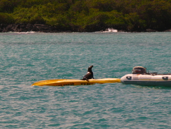
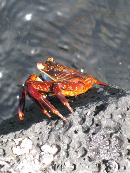
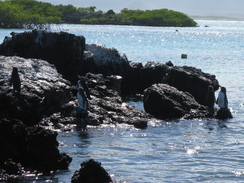
There was so much diverse wildlife on Isla Isabela. We found it remarkable to be on an island that was home to both pink flamingoes, which are tropical birds, and penguins, which are normally found in the arctic regions. There were penguins in the anchorage, and we occasionally saw one swim by Slip Away - what a sight! We also saw lots of blue footed boobies, frigate birds, finches, marine iguanas, lava lizards, sea lions, sally lightfoot crabs, land tortoises, sea turtles, eagle rays, manta rays and white-tipped sharks. It was a wildlife bonanza!
|
|
|
|
|
|
|
|
|
|
|
|
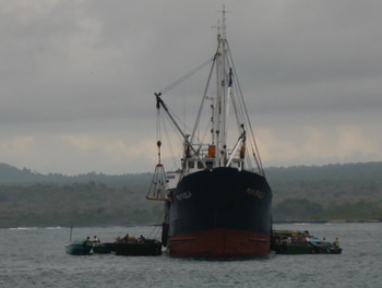
| While we were enjoying the sights of Isla Isabela, we were also preparing for our next passage, the three-to-four week voyage to the South Pacific. We had a number of chores to complete to get the boat ready for the passage (clean the bottom, change the oil in the main engine and generator, defrost the fridge and freezer). We also had a few errands to run in town - check out with the port captain and buy a few provisions. For such a small town, Puerto Villamil had a good selection of the items we needed to buy (fruits and veggies, bread and eggs), and we found pretty much all that we wanted. Breads and pastries were baked fresh daily and sold in a couple of bakeries (although the hours of the bakeries were sometimes hard to figure out!). A weekly supply boat arrived every Sunday, and it was a good idea to shop shortly after its arrival for the best selection of other items. Watching the locals unload the supply boat provided a full day's worth of entertainment. They used small barges that they pushed with their lanchas, and they would motor by us in the anchorage with the barges and/or lanchas loaded down with everything from fruits, veggies and meats to television sets and refrigerators. |
|
On June 3, we were ready to leave. Just before sunset, we "slipped away" from the anchorage at Isla Isabela, and pointed west-southwest toward the Marquesas Islands of French Polynesia, some 2900 miles away. We thoroughly enjoyed our visit to the Galápagos Islands. We feel very fortunate to have had the opportunity to visit such a unique and interesting place.